Parish: Wollongong
County: Camden
Gwynneville is a suburb west of the Wollongong city centre.
Local communities of Aboriginal people were the original inhabitants and Traditional Custodians of Illawarra Land. Their dialect is a variant of the Dharawal language.
Before European settlement, the Aboriginal people of the region lived in small family groups with complicated social structures and close associations with specific areas.
Suburb boundaries do not reflect the cultural boundaries of the local Aboriginal community.
Traditional Custodians today are descendants of the original inhabitants and have ongoing spiritual and cultural ties to the Land and waterways where their ancestors lived.
Gwynneville was originally part of a grant to James S Spearing called 'Paulsgrove' or 'Mount Keira Estate'. The Mount Keira Estate extended westward from where the railway line is now located.
Gwynneville is one of the older subdivisions in the Wollongong Municipality. It is thought to be named after John Gwynne, a farmer in the area. Allotments from the Gwynneville Estate were advertised for sale in the Illawarra Mercury on 12 November 1889.
James Stares Spearing and 'Paulsgrove' 1884
According to the 1828 census, James Stares Spearing "came free" to Australia in 1825. Upon his arrival he received promises of two grants, each of 1,000 acres, from Governor Brisbane. These became portions 7 and 8 of the Parish of Wollongong, and were known as the 'Paulsgrove estate'. Portion 7 extended west from Foley's Road to about half way up Mount Keira and south from Lysaght Street, North Wollongong, to Wiseman Park, Gwynneville.
The 1832 census credits Spearing with 400 acres of cleared land and 250 acres of cultivated land, as well as 5 horses, 50 cattle and 111 sheep.
In the 1832 Australian Almanac, Spearing was noted as being the "principal agriculturalist of the district". He had a beautiful garden well stocked with fruit trees and vegetables, two water mills and a windmill, with tradesmen employed at them. By 1830 he had had up to 61 convicts assigned to him, who performed most of the manual work on the property (Paulsgrove Diary, 1988).
In December 1835, the Paulsgrove properties were conveyed to Lt Colonel John Thomas Leahy, who changed the name to Mt Keera. On his death in 1839 the property passed to his heir, his brother Daniel. Daniel conveyed the property to Robert and Charles Campbell in 1841. In accordance with the trusts of sale, the Campbells subdivided the estate into a large number of smaller housing and farm lots. These were sold piecemeal over the next few years. The subdivision was known as the Mt Keera Estate subdivision (Paulsgrove Diary, 1988).
Mt Keera Estate subdivision, 1842
Maps of the area at this time confirm that the Mt Keera subdivision roughly encompassed Gwynneville in Lots 60-80 found north and south of Gipps Road, and Lots 85-90 found north of Murphy's Road and adjacent to Gleniffer Brae. Lots 66-70 encompassed the Dobing's bush area (Gwynneville, [18--], [map]; Plan of Mount Keera Estate [map], 1842; Plan of Mount Keera Estate (2nd edition) [map], 1889); Subdivided land at Gwynneville [map], 1890.
Further subdivisions
- In 1929, 50 residential lots with tarred and metalled roads, town water and electric light were advertised. They were encompassed by Kiernan Street, Gipps Road, Crawford Avenue and Foleys Flat Road.
- In 1937, 30 blocks along southern Porter Street were released.
- In 1938, the 'Mountainview Estate' was developed along Eastern Avenue.
- Also in 1938, there was a subdivision bordered by Frances Street, Foleys Road, Fairy Creek and Murphy's Lane (now Hillview Avenue). The advertisement notes that a regular bus service was available.
- Wiseman's Park was also further subdivided in 1938.
- In 1940, the 'Sunnybank' estate along Murphys Road, perpendicular to Eastern Ave, was released. It contained 24 sites with electric light, water and gas.
- In 1941, a further 38 sites were offered in W J Robinson's subdivision. In the advertisement for the land sale, the area is described as the "most popular and progressive residential centre in Wollongong".
(Robinson's 1st subdivision [map], 1924; W.J Robinson's 2nd subdivision [map], 1927; W J Robinson's 3rd subdivision [map], 1929; Robinson's 5th subdivision [map], 1937; Mountainview Estate, Woodlawn, Wollongong [map], 1938; Gwynneville - Frances Street [map], 1938; Wiseman's park 3rd subdivision [map], 1938; North West Wollongong [map], 1939; Sunnybank - North Wollongong [map], 1940; Robinson's 10th North Wollongong Station subdivision [map], 1941; Greater Wollongong City Council - Central districts [map], 1949).
Gwynne family
The Gwynne family have a long connection with the area. They first acquired 100 acres of land within the Mt Keera subdivision, and held land well into the next century. Maps show that John Gwynne had property north of Gipps Street, on lot 72 of the Mount Keira Estate. This land encompassed Eastern Avenue, William (now Moore) Street, Fairy Street and John Street, and extended east to Foleys Road and north to Murphys Avenue. (Gwynneville, [18--], [map]; Plan of Mount Keera Estate, 1842; Plan of Mount Keera Estate (2nd edition) [map], 1889; Subdivided land at Gwynneville near Wollongong [map], Gwynneville 1890).
John Gwynne was heavily involved with operations at the Mount Keira mine, and was injured by a runaway skip on the mine tram line in 1888 (Illawarra Mercury, 14 June 1888). He also participated in an 1894 survey of the Illawarra area with noted local surveyor Carl Weber (Illawarra Mercury, 18 March 1932). His will, probated in 1911, describes him as a farmer of the Gwynneville area and notes that he left all of his land to his wife, Anne Gwynne (Probate of will of John Gwynne [Manuscript]).
Edward Oxenbridge
Edward Oxenbridge was born in Camden in 1839. From the age of 15, he made the daily trip from Appin down the Mount Keira pass to Wollongong on horseback, in order to deliver Her Majesty's mails.
In The Pioneer Sourcebook he remembers John Gwynne of the Gwynneville Estate who worked with him in the mail distribution. He also describes one occasion when he was held up by a bushranger (Organ & Doyle, 1989, p87-89).
The Shipp family
William Shipp arrived in Australia with his brother in about 1851. The Shipp family established a connection with the Gwynneville area through their residence at Mount Keira at a time when "all the area west of Wollongong was known as Mt Keira" (Organ& Doyle, 1989, p81).
William Shipp worked for a while in the Wollongong area, before settling with his family in Gwynneville / Keiraville. He became associated with the Mount Keira Colliery when he helped to build the rail incline down to the harbour. He also assisted with the braking of the wagons down that incline.
His brother Thomas came to the area a little later, and worked in the colliery as a carpenter (Organ & Doyle, 1989, p81).
The McGoldricks
The Shipps also describe other residents of the area at the time. They note that amongst the old families of Mount Keira must also be mentioned James and Thomas McGoldrick (Organ & Doyle, 1989, p81).
James McGoldrick was described as a miner in an abstract to the title of allotment 17 - 18 of Gwynne's 1924 subdivision, lots 71 & 72 of the original subdivision of the Mount Keira Estate (Abstract of the title of James McGoldrick, 1924).
According to a 1920 map, the McGoldricks lived in Moore Street, (Robinson's 1st subdivision [map], 1924). Mrs McGoldrick along with T J Gillis and Frank Gray, is also mentioned as one of the main workers at the Gwynneville School of Arts (Illawarra Mercury, 9 March 1934).
Other residents
The Pioneer Sourcebook notes that amongst the old families who purchased farms on the original Mount Keira estate were Denis Foley, Denis Williams, Mr Young, Percy Owen, William Northfield, Mr Zlotkowski, John Stewart, William Robson, John Gilmore, Hugh Higgins and John Spence.
With very few exceptions, the old holdings have changed hands. In some cases they have been cut up into smaller areas and re-sold (Organ & Doyle, 1989).
One of these residents, Mr Young, later gave a lecture in the School of Arts describing 1870 as he remembered it (Organ & Doyle, 1989, p.151).
Mr James Dean of Crown Street also describes many of the settlers in the area west of Wollongong, including Billy Ahearn, Dennis Foley, William Gwynne, Dennis Williams and Walter Buckle. He describes how on moonlit nights he would shoot opossums at Wiseman's Park, and notes that birds of every kind frequented the area.
He describes how at the top end of this park Mr Walter Buckle had a fine orchard containing some beautiful fruit, where the residents of Wollongong would often take a walk to gather fruit (Organ & Doyle, 1989, p151).
As noted above, James Spearing was a noted early agriculturalist in the area. After the subdivision of his land the area continued to be used for agricultural purposes. A number of small farms used the land for grazing and producing different items ranging from oats, barley, maize and potatoes to fruit and other crops (Yewen, 2004, p551-552).
Later, the area became noted for its association with the Mount Keira Colliery and the Hoskins-Australian Iron and Steel Works. The tram line which conveyed coal to the harbour passed directly through Gwynneville, and many locals were involved in the operation, upkeep and maintenance of the line (Raxworthy, Oral history; Illawarra Mercury 20 July 1860, 26 October 1860 & 4 October 1888; Illawarra Historical Society Bulletin, November-December 2000, p 84-91).
The Federal Cokeworks was on the site now occupied by Beaton Park. It employed 32 men at the end of 1911. The adjacent gas works also dominated industry in the area (South Coast Local History, Wollongong at work resource Kit, no3, transport changes, Dept of Education Professional Services Centre, 1978. p 27; Raxworthy, Oral history).
On the site of Wiseman's Park a small brickworks operated for a number of years (Organ & Doyle, 1989, p 156).
By the early 1920s, the business district of Wollongong was developing along the Princes Highway. A 1924 subdivision encompassing the western side of the Princes Highway and Gipps Street is described as prime land for business purposes (Robinson's 1st subdivision [map], 1924).
Some later local businesses included:
- S.A Denison & Sons, championship bread makers specialising in wheatmeal, located on Foley's Road. Their premises were built in 1939, and Mr Denison had to work long hours due to the labour shortage created by WWII. He worked through the night with the inside staff and delivered throughout the day. Improvements made in 1947 included an oil fired oven, more space, new carts and more horses. The bakery won numerous championships in all open classes of bread for many years running (South Coast Times, June 11, 1951).
- The South Coast Nursery, on Foley's Road. The nursery were reputed local growers and producers of high quality flowers, fruits and vegetables (South Coast Times, 11 June 1951).
- The grocery store known as Martin's Corner, Foley's Road. The store was well stocked with locally produced fruit and vegetables, and operated a delivery service throughout the Illawarra (South Coast Times, 11 June 1951).
In the 1860s, the Illawarra district was re-zoned into municipal government areas. Gwynneville became part of the municipality of Northern Illawarra. At this time there were some important roads of considerable length which linked east and west in the district, including Foleys Road, Murphys Lane and Northfields Lane (Organ & Doyle, 1989. p 62).
In 1908, Gwynneville itself was approached by a narrow track, rather then a proper one lane roadway (Illawarra Mercury, 23 October 1908). By the 1920s, Gipps Road had been established and a 1920s map notes that it was 66 feet wide (W.J Robinson's 2nd subdivision [map], 1927). By 1934 this road was constructed of bitumen, and was the main road linking the Princes Highway and Keira Village (Keiraville) (Illawarra Mercury, 9 February 1934),
There were many land subdivisions in the Gwynneville area throughout the 1950s. Advertisements for land in these subdivisions note that facilities included electricity, light, water, tarred and metalled roads and a regular bus service (Robinson's 1st subdivision [map], 1924; W.J Robinson's 2nd subdivision [map], 1927; W J Robinson's 3rd subdivision [map], 1929; Robinson's 5th subdivision [map], 1937; Mountainview Estate, Woodlawn, Wollongong [map], 1938; Gwynneville - Frances Street [map], 1938; Wiseman's park 3rd subdivision [map], 1938; North West Wollongong [map], 1939; Sunnybank - North Wollongong [map], 1940; Robinson's 10th North Wollongong Station subdivision [map], 1941; Greater Wollongong City Council - Central districts [map], 1949).
The Gwynneville area was separated from the city by the main South Coast rail line, which bordered Gwynneville on the eastern side. The Gwynneville people were part of a group instrumental in having a railway platform established at North Wollongong from the late 1800s (Illawarra Mercury, 26 July 1887).
Elonera and adjacent private residence
Address: 31 and 33 Foleys Road
Originally a doctor's surgery, Elonera, the tudor house at 33 Foleys Road, was established as an alternative school in 1973. It became the home of Wollongong's first Montessori Primary School in 1987. From its inception as a single teacher class of 15 students in 1987, the school grew to provide a number of classes by the late 1990s. To accommodate this growth, they purchased the adjacent house which is listed on the NSW heritage register. Later, the school expanded into provision of secondary schooling and moved to Mount Ousley (Gwynneville Local cuttings file; NSW Heritage Office).
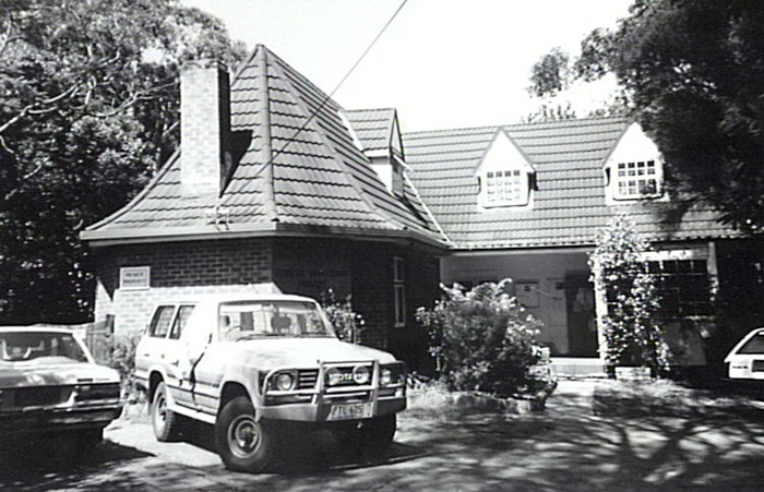
Image: Elonera, 1994, image number P11357.
Gipps Street Army Depot Memorial Wall
A wall memorialising the contributions made by citizen soldiers of the Illawarra during both peace and wartime is located in the Gipps Street army depot in Gwynneville. It was dedicated in October 2000 by Edward Kenna, one of the three surviving Victoria Cross holders in Australia at the time, and came about through the efforts of The Association of Fourth Infantry Battalions Illawarra sub-branch. On the same day, the training depot was named after Major General Gordon Maitland who was a prominent World War Two leader (Illawarra Mercury, 9 October 2000).
School of Arts Hall and Wollongong Workshop Theatre
In 1934, a small hall of 36 x 25 feet was opened as a School of Arts opposite Wisemans Park. The idea for the hall was conceived when "a few progressive spirits held a meeting on a log in the bush" in 1925. Planning and lobbying was then carried out by the North Wollongong Progress Association School of Arts Committee (Illawarra Mercury, 9 March 1934; South Coast Times, 9 March 1934).
The hall is now located at the rear of the Senior Citizens Centre, and is used by "Wollongong's oldest theatre group", the Wollongong Workshop Theatre, established in 1953 (St Brigid's 40th Anniversary Souvenir Book, 1988; Theatre in the Illawarra database).
Gwynneville Public School
The first classroom at Gwynneville Public School was built in 1952. It was one of about 1,500 classrooms of the type which were manufactured in England by the Bristol Aeroplane Company and imported between the 1950s and 1960s (Irving, 2001,p. 98).
Old English homes
According to Robert Irving "Wollongong has a small number of interesting houses designed in the Old English style of architecture", a good example of which can be found in Acacia Avenue Gwynneville. Though small and modest, the house captures the character of the style, with its precise dark brickwork, steep and gabled main roof, 'catslide' porch, repeated round arches, corbelled eaves, leaded upper sashes and buttress form chimney (Irving, 2001, p. 60).
Churches
St Brigid's Catholic Church in Gipps Road was designed by Sydney Hirst and built by A W Edwards group. It is typical of ecclesiastical architecture of the post war period, displaying a religious character without the elaborate ornamentation of Gothic Revivalism. Its narthex, lofty gable and tall windows displays a no-nonsense interpretation of medieval architecture. It is also interesting to note that the light straw coloured bricks are "reputed to have been the first of their kind to be made at Bulli Brickworks" (Irving, 2001, p.87).
It is interesting to compare this to St John's Anglican Church found on the corner of Eastern Avenue and Moore Street, designed by Robert M Wilson and built in 1972 by Osron Constructions. While it also displays the modern simplicity of such buildings in the post war period, its main structure is low slung with horizontal emphasis that contrasts with the vertical spire motif of the building's corner (Irving, 2001, p. 118).
Gwynneville is a predominantly urbanised suburb located within two kilometres of the city centre, and adjacent to the University suburb of Keiraville. A mixture of brick and tile and fibro cottage style single family residences and town-house, villa and unit style multi residential dwellings dominate the area.
Some small commercial premises and community facilities are also located in the village shops located along Gipps Road.
Gwynneville contains the junction of three major South Coast roads: the M1 Motorway (previously called the Southern Freeway, F6), Mount Ousley Road and Memorial Drive (previously called The Northern Distributor). The interchange bisects the suburb and involves heavy private and industrial through-traffic.
Despite its high density urbanisation and the existence of major traffic infrastructure in the area, Gwynneville retains some important environmental features. It is an essential part of the Keira Green Corridor. Its location between the foothills of Mount Keira and the city makes it an essential link between the prominent escarpment and its associated geography and the flatter urbanised area that is the city.
The streets are well populated with greenery. There is abundant birdlife and a number of bushlands and parks dot the area. Wisemans Park and the adjacent bushy reserve are a prime example of this. Patches of remnant native grasses dot the park, and a large number of native species grow here including:
- Grey Ironbark (Eucalyptus paniculate)
- Turpentine (Syncarpia glomulifera)
- Prickly paperbark (Melaleuca styphelioides)
- Blackbutt (Eucalyptus pilularis)
- Woollybutt (Eucalyptus longifolia)
- White stringybark (Eucalyptus eugenioides)
- Forest Redgum (Eucalyptus tereticornis) (Davis, 1992).
In addition, one of the rarest plants in the Illawarra, Rulingia dasyphylla, grows here, and the Ironbark orchid, Dendobrium Aemulum, has been sighted here (Illawarra Mercury, 27 June 2001).
The mature trees of Wisemans Park can be considered a nursery for future growth. As part of the local regeneration project, their seed is collected for the generation of saplings which are raised at Wollongong Botanic Garden. The older and decaying trees also provide important habitat for native fauna (Environment Illawarra, 1992).
Fairy Creek is another important feature of the Gwynneville environment. It is the last continuous link between the escarpment and the ocean within the Keira Green Corridor. It drains an area approximately 7.6 square kilometres (Environment Illawarra, 1992).
Branches of the creek pass through Gwynneville at three locations:
- Near the Eastern end of Murphy's Avenue, then Spearing Parade and Irvine Street, then the foot of the M1 Motorway
- Near Waitangi Street and the M1 interchange, then Robinson Park near North Wollongong station
- Near Acacia Avenue and adjacent bushland reserve, then Wisemans park and Beaton Park.
A January 2000 study of the Waitangi Street site identified a total of 171 plant species, 69% of which were introduced, 25% of which were regional native species, and 6% of which were native but not regional. The natives encompassed 51 species, with Eucalyptus and Wattle types predominant.
The site was also identified as a refuge for various species of native flora, predominantly self seeded wattles, and fauna, including 94 species of vertebrate fauna across 45 families of fish, frog, reptile, bird and mammal. 85% of these were native, predominantly birds, and three species were observed to be breeding at the site.
Of particular conservation significance, the Grey-headed Flying Fox (Pteropus pliocephalus) was observed to be using the site (Zammit, 2000).
| Date | Event |
|---|---|
| 1825 | James Spearing arrived in Australia to take up his land grants, one of which comprised the Gwynneville area |
| 1832 | Spearing noted as pre-eminent agriculturalist of the area |
| 1835 | Spearing's estate conveyed to Lt Col Leahy, who changed the name to Mt Keera estate |
| 1842 | Mount Keera estate subdivision, roughly encompassing Gwynneville in lots 60-80 |
| 1861 | Mount Keira tramway line opened. |
| 1888 | John Gwynne injured by a runaway skip on the Mt Keira tramline |
| 1889 | The Illawarra Mercury advertised allotments for sale in the Gwynneville Estate |
| 1900 | New coke works erected at Beaton Park site |
| 1908 | Dobing's bush sold to the city council |
| 1908 | Gwynneville approached only by a narrow track |
| 1911 | Federal Coke Works employed 32 men at year's end |
| 1912 | Dobing's bush gazetted |
| 1920 | Gipps Road was 66 feet wide |
| 1924 | Gwynne's subdivision of his parcel of land, comprising lots 71 and 72 of the original Mount Keera subdivision |
| 1925 | Recreation ground established at Wiseman's Park, sports oval opened, planning for future School of Arts commenced |
| 1929 | Kiernan Street subdivision |
| 1934 | Gwynneville School of Arts hall opened |
| 1937 | Porter Street subdivision |
| 1938 | Mountainview estate subdivision along Eastern Avenue, Frances Street subdivision and Wiseman Park subdivision |
| 1939 | S A Denison and sons bakery established on Foley's Road |
| 1940 | Sunnybank estate subdivision along Murphy's Road |
| 1941 | St John's Church of England, Gwynneville dedicated |
| 1941 | Robinson's 10th subdivision |
| 1948 | Council negotiations for the acquisition of land at Beaton Park commenced |
| 1948 | Cardinal Gilroy appoints first Rector Amovibilis of Gwynneville |
| 1951 | St Brigid's Catholic Church opened |
| 1952 | Second bowling green opened at Wiseman Park |
| 1952 | First classroom at Gwynneville Public School built |
| 1952 | Scout club room opened |
| 1953 | Wollongong Workshop Theatre established |
| 1953 | St Brigid's Primary School opened by Bishop McCabe |
| 1953 | Greenacres school opened by Mr Sid Hoskins, president of the Wollongong Subnormal Children's Welfare Association |
| 1954 | Mount Keira rail line dismantled |
| 1955 | Beaton Park area set aside by council for future recreational development |
| 1963 | St Brigid's Catholic Women's league established |
| 1963 | South Coast synagogue and community centre for the local Hebrew community opened in Gwynneville |
| 1971 | Federal Coke Works shut down |
| 1973 | "Elonera" at 33 Foley's Road established as an alternative school |
| 1978 | Illawarra Preschool Committee opened a preschool in Berkeley Road, Gwynneville |
| 1981 | Beaton Park Leisure Centre opened |
| 1983 | Beaton Park heated pool opened |
| 1987 | Elonera established as Wollongong's first Montessori Primary School |
| 1989 | Throsby Drive constructed |
| 1993 | Beaton Park athletics track opened |
| 1998 | Heritage house adjacent to Elonera purchased by the Montessori school to expand services |
| 2000 | Gipps Street army depot memorial wall dedicated |
| 2001 | Beaton Park grandstand opened |
| 2007 | Traffic lights installed at Gipps Road and Foley Street intersection in November (Illawarra Index) |
Abstract of the title of James McGoldrick of Wollongong, miner, to allotment 18, section 1 of Gwynne’s subdivision of the original subdivision of the mount Keira Estate [manuscript], Wollongong: d'Apice & d'Apice, Solicitors, 1924.
Illawarra Historical Society Bulletin, Wollongong, NSW: Illawarra Historical Society, 1945-
Illawarra Mercury, Wollongong, NSW: Illawarra Newspapers Holdings, 1856-
Irving, Robert, Twentieth Century Architecture in Wollongong, Paddington, NSW: Barbara Beckett Publishing for Wollongong City Council, 2001.
Environment Illawarra: the Keira Green Corridor, Wollongong, NSW: Wollongong City Council, 1992.
Local Studies Cuttings File.
NSW Heritage office. Available from: http://www.heritage.nsw.gov.au/07_subnav_01_2.cfm?itemid=2700655, [Accessed 25/7/2005].
Organ, M & Doyle, A. P., Illawarra Historical Source books Old Pioneer’s reminiscences of Illawarra (1830s-1920s), Woonona: Illawarra Historical Publications, 1989.
Paulsgrove Diary, Illawarra 1833-1834 (with intro & notes by W.G McDonald), Wollongong: Illawarra Historical Society, 1988.
Probate of will of John Gwynne late of Gwynneville (died 1907) [manuscript].
Rankine & Hill, Consulting Engineers. Wollongong Sporting Complex: A study, Wollongong: Wollongong City Council, 1976.
Raxworthy, Richard, Mount Keira Mine tramway workers - oral history [manuscript].
South Coast Local History, Resource Kit No3: Wollongong at work, Department of Education Professional Services Centre, 1978.
South Coast Times [microform], Milsons Point, NSW: W. & F. Pascoe, [n.d.].
Souvenir book to commemorate the 40th anniversary of St Brigid’s Gwynneville – A tribute to its Clergy, Pioneers & Parishioners, 1948-1988, [Wollongong]: St Brigid's Catholic Church, Gwynneville, 1988.
Beaton Park Plan of Management, Wollongong: Wollongong City Council, 1996.
Yewen, Alfred G, Yewen's directory of the landholders of New South Wales (1900) [electronic resource], Modbury, S. Aust: Archive CD Books Australia, c2004.
Zammit, Phillip, J, Flora and vertebrate fauna of Fairy Creek between Gipps Road and Murphy’s Avenue, Gwynneville, New South Wales, [Wollongong]: RTA, 2000.
Top image: Northfields Lane, Gwynneville. See image details on our catalogue