Parish: Bulgo
County: Cumberland
Otford is a small suburb in the far north of the Wollongong Local Government Area, near the Royal National Park.
Local communities of Aboriginal people were the original inhabitants and Traditional Custodians of Illawarra Land. Their dialect is a variant of the Dharawal language.
Before European settlement, the Aboriginal people of the region lived in small family groups with complicated social structures and close associations with specific areas.
Suburb boundaries do not reflect the cultural boundaries of the local Aboriginal community.
Traditional Custodians today are descendants of the original inhabitants and have ongoing spiritual and cultural ties to the Land and waterways where their ancestors lived.
Otford was formerly known as Bulgo. Bulgo appears to have been first marked on Robert Dixon's 'Map of the Colony of New South Wales' in 1842 and the name continued in use for some time.
Construction of the Illawarra line, north of Clifton, brought the appearance of a village here in early 1885. Trains on the Illawarra line stopped here to take in water and a small railway and sawmill centre developed at the mouth of the Otford tunnel.
The name of the village changed to Otford in May 1885. Otford was probably named after the historic village of Otford in West Kent, England, the name meaning "otta's ford".
Land grants
North of the town of Wollongong, the land was originally granted as a large parcel which included Coalcliff, Stanwell Park and Otford (then known as Bulgo). The 1,000 acres was promised to Matthew John Gibbons for grazing in 1824. The property then passed to William Bucknell in 1838, then to Surveyor-General and explorer Sir Thomas Mitchell in 1848. Eventually the property was purchased by John Fletcher Hargrave in 1872 (Bayley, 1989. Adams, 1986?).
Two parcels of land totalling 326 acres, located north of Bald Hill, were granted to John Dwyer and G. W Newcombe in 1840. However the land was not developed and was resumed by the New South Wales Government to preserve the pristine nature of the coastline. Only in the valleys were the grants suitable for grazing, as the steep hills were covered in sub tropical rainforest which became a source of the best cedar trees found within Australia at the time (Bayley, 1989: Adams, 1986?: The Helensburgh & District Historical Society, 2006).
John Fletcher Hargrave (Judge) and Gilbert Hargrave
John Fletcher Hargrave, father of Lawrence, the famous aviation pioneer, was a Supreme Court Judge as well as a member of the Legislative Assembly for the electorate of East Camden which extended to the coast (Grainger, 1978). He purchased the land parcel from Mitchell with a view to develop the coal reserves located at the southern end of the property known as The Coal Cliffs. However, with the rugged terrain surrounding the area, he had difficulty in attracting capital to help with the development of a mine and a jetty to export the coal. As a result, he let the idea go, instead enjoying the beauty of his property by building a holiday house at Coalcliff (Adams, 1986?).
John Hargrave is said to have named his farm Otford after the previous home in Otford, Kent as its surroundings reminded him of his former home (Illawarra Mercury, 31 August 1996 p.46). Hargrave divided his estate between his four children. In 1884 his son Gilbert inherited property at the southern end of Otford that included 40 acres and a lease of a further 311 acres with the option to compete the purchase later.
Gilbert was not very good at managing money and did not finish the larger purchase. He mortgaged the 40 acre property to Eugene Nicholls and eventually surrendered to it to him in 1893. During his time at the property Gilbert supplemented his income by transporting timber to the Coalcliff mine (and possibly to the new mine in Helensburgh) by bullock team. There are many accounts that Gilbert named one bullock "Jesus" and the other "Christ" so that the locals could not "distinguish the swearing from gentle encouragement to his team" (Adams, 1986?, p.77; Fletcher & Rook, 1985).
Gardiner Family
William and Agnes Gardiner were known to be living in the Otford area by 1867. The couple brought up their family of six sons and three daughters on the property. The family used the land to make wine, train horses and raise goats for milk, as there were not many cows in the area at this time.
The children were sent to stay with friends and family at Bulli for their education as there was no school at Otford. William's son Patrick later became one of the signatories of the petition to open a school at Otford. The family were known to be the "life of the party" and very popular within the community (Fletcher & Rook, 1985).
Other early residents
Other early residents were William and Margaret Hamilton who purchased 304 acres and built a 15 room residence, and Thomas Hall James who purchased a property of 320 acres in 1864 (Fletcher & Rook, 1985; Adams, 1986?).
Timber Mill
The first mill within the Otford valley was established by Thomas James and his three brothers in 1875 at the northern end of Otford. James Forster also created a mill at the southern end of Otford in 1899. The sound of the sawmills echoed around the valley as men cut and prepared timber for use in the local coal mines and for housing in the area (Adams, 1986?; Fletcher & Rook, 1985).
Services
In 1885 the building of the railway line transformed the sleepy town of four houses and a public house (a combined store and inn) overnight to become a busy community with over 100 men employed to create bricks for the construction of tunnels, and the actual construction of the line. Accommodation for many of the workers was in the form of tents. Many of the workers originally came from Italy, so the camp became known as 'little Italy' (Adams, 1986?, Bayley, 1989. Fletcher & Rook, 1985).
In 1885 a school was built for the local children, who originally had to travel to Clifton for school fives miles to the south of the village. The post office opened in 1885 and with the growing population many retailers moved into the area. A police constable was stationed to the town in 1886 but was later withdrawn in 1887. By 1887 the village had a hotel, as well as butchers, bakers, tailors, jewellers, and a general store. Entertainment came in the form of a billiard room and a skittle alley. Often on pay day a mobile tailor would visit the camps to measure the workers for new suits (Adams, 1986?; Bayley, 1989; Fletcher & Rook, 1985).
After the completion of the rail line, the population of the village declined as most of the workers and their families moved on. The school closed in May 1893. The Inspector for Schools made the decision to close the school as the small number of children remaining in the village could travel on the train safely to Helensburgh or Clifton. However, the travelling public did not appreciate the less than perfect behaviour of the children and many complaints were made. In 1895 the number of children of school age in the town had increased to 34 so the parents successfully petitioned to have the school reopened (Fletcher & Rook, 1985).
Mushroom Industry
Lilyvale Mushrooms Pty. Ltd. is the largest growing mushroom firm in Australia. It began in 1952 in a very small single tunnel at Lilyvale and in 1959 two tunnels were in operation. 80 to 90 crops are grown per year and 80 percent of the production is canned and the remainder is sold fresh (History of Helensburgh, 1978).
Railways
The announcement of the building of the railway line in 1881 was welcomed by the people of the Illawarra as the demand for a safe transport route between Sydney and the Illawarra had been constant. Other routes were by the sea in small craft where the travellers were subject to sea sickness on unpredictable seas and weather conditions; or overland via Bulli pass which was so steep, fit and healthy passengers were expected to walk the mountain pass then travel to Campbelltown by coach, to complete the journey by rail. A reliable rail link would also help transport coal to Sydney (Adams, 1986?).
The line between Waterfall and Clifton took the longest time and was expensive to build because of the construction of seven tunnels and the rugged terrain of the area. This section of work delayed the opening of the line to Illawarra by two years and used over 18 million bricks for the construction. During the construction of the largest tunnel through Bald Hill at the southern end of Otford (1500 metres), teams had to work in continuous shifts to complete it (Adams, 1986?; Singleton, 1970).
The first steam locomotive travelled from Sydney carrying first and second class passengers for the official opening celebrations in North Kiama on 3 October 1888. The line was well used, especially for day trips and by holiday makers, as the south coast became more accessible for people from Sydney. Larger towns to the south also noted an increase in trade from the previously isolated north (Bayley, 1989; Singleton, 1970).
However, travel through Otford tunnel became known as being very unpleasant during the long steep climb back to Otford. There were no lights in the carriages so the passengers had to sit in the dark, and the thick smoke and soot poured in through gaps and under the doors. Passengers in the third class section had no windows or shelter against the choking soot as the train crawled at a snail's pace up through the hill. The enginemen suffered the most, as they had to travel the length of the tunnel crouching on the floor to avoid the heavy soot and smoke (Adams, 1986?; Bayley, 1989; Singleton, 1970).
The tunnel's notoriety increased on a busy day in October 1890 when a 12 car train stalled in the tunnel. Eventually the engineman had to reverse the train to Stanwell Park and divide the train into halves to be taken through the tunnel. The fear of the tunnel grew following reports of accidents and engines stalling more frequently. Finally the decision was made in June 1917 to move the line and construct a new tunnel with an easier incline of 1:80 compared with the original tunnel's 1:40. This was completed in 1920 and is the same line that is used to this day (Adams, 1986?; Bayley, 1989; Singleton, 1970).
Road
"The first road to the Illawarra came from Campbelltown, through Appin. The road branched, one heading for Bulli, the other through Darkes Forrest, down Mount Mitchell to Stanwell Park and along the coast to Wollongong. Even after the construction of the Illawarra Road in 1850, most people continued to use the western approach to Wollongong" (The Helensburgh & District Historical Society, 2006). It was suitable for bullock and coaches. An alternative path to Syndey was by a saddle track along the coast, up Bald Hill and along the Bulgo Range and through to Bundeena on the shores of Port Hacking (Adams, 1986).
Otford Road was commenced in 1905 as a direct link between Otford and Helensburgh, and was abandoned in about 1916 because it was steep, unsafe and costly to maintain. The bush track was used by bullock teams to transport timber to the mine. Helensburgh was consequently only accessible via Bald Hill until around 1970 as modern cars were now strong enough to handle steeper grades (Fletcher & Rook, 1985; History of Helensburgh,1978).
During the depression years the State Government created a road building program to support many unemployed men. One of the major construction projects was the building of Lady Wakehurst Drive through the Royal National Park in 1937-1939. The men were divided into teams that worked alternative weeks which allowed families to live on a weekly wage over a fortnight (Fletcher & Rook, 1985).
Former Post Office
Address: 7 Otford Road, Otford
The former Post Office is a single storey weatherboard dwelling with verandahs and a corrugated metal roof. The building has an important association with the urban development of the Otford community at the turn of the century.
The building was moved 100 metres south from its original location as the site was in line of railway deviation construction in 1918.
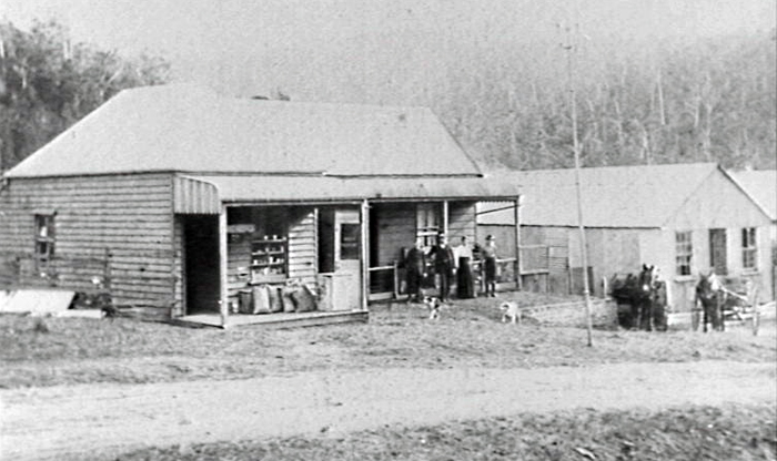
Image: Otford Post Office ca. 1914, image number P02520.
House
Address: 35 Station Road (opposite Primary School)
This house is of painted weatherboard, with a corrugated steel roof, 'wrap around' verandahs, window hoods, strutted off walls, and brick chimney. This house is an excellent example of rural timber vernacular around the turn of the century. It is the former headmaster's residence.
Semi detached houses (railway cottages)
Address: 4, 5, 6, 7 Lady Carrington Road, Otford
Two pairs of semi detached brick and corrugated steel roofed houses are located on Lady Carrington Drive. They feature flat sheet sun-hoods over side and front windows.
These buildings are an example of simple solid vernacular architecture associated with the establishment of Otford as a small village on the South Coast rail line. The buildings are in good condition and have changed very little (City of Wollongong Heritage Study, 1991).
Otford's location in a valley has protected it from major development. Most of the residences within the village have been built on the hillsides. Through the centre of the village runs the Hacking River, which flows into the Royal National Park to the north.
Otford's close proximity to the Royal National Park, an environmentally sensitive and protected area, means that any further development must be carefully planned to ensure the survival of local native flora, fauna and native wildlife corridors.
Otford's surrounding area is home to many unique species of flora and fauna. The valley's surrounding hills are part of a subtropical and warm temperate rainforest made up of tall eucalypt trees. Other flora species found include "stands of cabbage tree palms, coachwood and sassafras as well as wonga-wonga vines, wombat berry, settler's flax and shiny fan ferns" (Sydney Morning Herald, 8 February 2004). After a history of logging in the area, many of the trees are finally regenerating.
Native fauna in the area includes many birds such as "wedge-tailed eagles, black shouldered kites, white-napped honeyeaters, crimson rosellas, pee-wees, red wattle- birds, sulphur-crested cockatoos and bronze wings" (Sydney Morning Herald, 8 February 2004). Mammals that live in Otford and the surrounding Royal National Park include bush rats, black rats, a range of gliders, bandicoots and ringtail possums. The area also is home to a number of reptiles and frogs. Introduced species of red fox, rabbits and Rusa deer also live in the area (Sydney Morning Herald, 2004. National Parks, 2006).
Future development of the Helensburgh and Otford area has been an important issue since the 1970s. In 1985 the State Government requested Wollongong City Council undertake a Local Environment Study to investigate urban expansion and its effect on the local environment. Also in 1985 there was a draft plan for the development of 2,200 lots in the Camp Creek and Gills Creek area and a 40 hectare site for commercial development on the town's outskirts. Council rejected the development plan after five years of debating because it could not guarantee that the Royal National Park and the Hacking river catchment area would not be polluted (Illawarra Mercury 20 April, 1991).
Some of the problems associated with further development of the Otford area are:
- Water supply from the Woronora Dam
- Waste disposal
- Bush fire hazards
- Introduction of exotic plants and domestic animals and the spread of diseases that may affect native animals and plants
- Contamination of the Hacking River, which flows through the National Park, due to sewerage waste, urban runoff, erosion from construction sites and also the scenic value of certain areas around the area
- Spread of feral animals into National Park because of its proximity (Helensburgh Local Environmental Study Progress Report, 1986; The Helensburgh Plan: Draft, 1989; Future Development of Helensburgh, 1984).
| Date | Event |
|---|---|
| 1824 | 1,000 acres was promised to Matthew John Gibbons for grazing |
| 1838 | Property purchased by William Bucknell |
| 1840 | 326 acres located north of Bald Hill were granted to John Dwyer and G. W Newcombe |
| 1842 | Bulgo appears to have been first marked on Robert Dixon's "Map of the Colony of New South Wales" |
| 1872 | Land purchased by John Fletcher Hargrave from Sir Thomas Mitchell |
| 1875 | First timber mill in Otford established by Thomas James |
| 1881 | Construction of the Illawarra railway line announced |
| 1884 | John Hargrave's son Gilbert inherits the southern end of Otford |
| 1885 | Name of village changed from Bulgo to Otford |
| 1885 | Otford School, and post office opens |
| 1888 | The Illawarra railway line opens from Sydney to North Kiama |
| 1893 | Otford School closes |
| 1893 | Eugene Nicholls takes possession of Gilbert Hargrave's estate |
| 1895 | Otford School reopens |
| 1905 | Otford road opens to provide a direct road to Helensburgh |
| 1916 | Otford road closes due to unsafe conditions |
| 1917 | Decision made to move Illawarra railway line and construct a new tunnel |
| 1920 | New railway line completed |
| 1937 | Construction of Lady Wakehurst Drive begins |
| 1939 | Lady Wakehurst Drive completed |
| 1945 | Electricity installed to Otford Progess Hall |
| 1946 | Otford Fire brigade formed |
| 1952 | Lilyvale Mushrooms Pty Ltd begins in disused railway tunnel |
| 1956 | Sydney Metropolitan Water Board supplies water to Otford |
| 1970 | Otford road reopens |
| 1979 | Post office closes |
| 1985 | Otford School celebrates its centenary |
| 2005 | Sydney Metropolitan Water Board connects sewerage system to Otford |
Adams, Michael. The history of Stanwell Park and surrounding districts of the northern Illawarra region until 1950, [s.l.: The Author?, 1986?].
Bayley, William A., Black Diamonds: History of Bulli District New South Wales, 2nd ed., Bulli, NSW: Bulli Public School, 1969.
Bayley, William A., Black Diamonds: History of Bulli District New South Wales, 4th ed., Wollongong, NSW: Illawarra Historical Society, 1989.
Fletcher, Jim & Rook, Ruth, Otford Public School Centenary, 1885-1985, Otford, NSW: Otford Public School Centenary Committee, 1985.
Grainger, Elena, Hargrave and Son: a biography of John Fletcher Hargrave and his son Lawrence Hargrave, St. Lucia, Queensland: University of Queensland Press, 1978.
Helensburgh and District Historical Society, website, accessed 11 July 2006.
History of Helensburgh, Helensburgh, NSW: Helensburgh Public School, 1978.
Irish, C. A., Names of Railway Stations in New South Wales, with their meanings and origin, in Journal of the Royal Australian Historical Society, Vol. XIII, Part 11, Sydney: Royal Australian Historical Society, 1927.
Illawarra Mercury, Wollongong, NSW: Illawarra Newspapers Holdings, 1856-
National Parks and Wildlife, website accessed 27 July 2006.
Reed, Alexander Wyclif, Place-Names of New South Wales: Their Origins and Meanings, Sydney: Reed, 1969.
Singleton, Cyril Corbet, Railway History in Illawarra, 2nd ed., Wollongong, NSW: Illawarra Historical Society, 1970.
Sydney Morning Herald, Sydney: John Fairfax Publications, 1831-
Wollongong City Council, Strategic Planning Section. The Helensburgh Plan: draft, Wollongong, NSW: Wollongong City Council, 1989.
Wollongong City Council, Planning and Development Department, Future Development of Helensburgh, Wollongong, NSW: Wollongong City Council, 1984.
Wollongong City Council, Planning and Development Department, Helensburgh local environmental study progress report, Wollongong NSW: Wollongong City Council, 1986.
Wollongong City Council, Planning and Development Department, Helensburgh local environment study progress report in Helensburgh Local Environmental Study Management Committee records and papers [manuscript] MSS 370/2, Wollongong, NSW: Wollongong City Council, 1986.
Top image: Otford, 1900. See image details on our catalogue